Imagine effortlessly navigating rugged terrains or pristine trails just by glancing at your phone or computer. By understanding how Google Maps provides elevation data, you’ll not only traverse new landscapes with ease but also ensure your travel adventures are planned to perfection, with all necessary precautions in place. Elevation details can significantly enhance your travel itineraries, providing insights into the terrain, influencing the routes you choose, and shaping your travel experiences. Let’s explore how this crucial data can be leveraged to tailor your adventures, whether you’re hiking, cycling, or embarking on a road trip.
Introduction
Elevation data on Google Maps is a treasure trove of topographical information that gives travelers insight into the altitude and relief of any given area. Understanding these elevation changes isn’t just for earth scientists; it’s incredibly beneficial for anyone wanting a deeper understanding of the terrain they plan to traverse. With Google Maps’ elevation capabilities, you can craft travel itineraries that not only account for the beauty of the landscape but also anticipate the challenges it presents.
What is elevation data on Google Maps?
Elevation data on Google Maps serves as an informative layer that enhances the way we interact with digital mapping. It illustrates the planet’s topographical variations and is invaluable for those needing details about altitude changes in various regions. Utilizing inputs from s like the United States Geological Survey (USGS) and NASA, Google Maps displays this data through contour lines and numeric altitude markers.
- Contour Lines: These are lines drawn on a map connecting points of equal elevation. They help visualize the ascent and descent of the terrain, offering a 3D perspective of a flat map. For instance, closely spaced contour lines indicate steep terrains, while wide-spaced contours suggest gentler slopes.
- Numeric Elevation Markers: These provide specific altitude readings for different points on the map, allowing users to see exact elevation changes. This feature is particularly useful when precise altitude data is necessary, such as when planning a hiking trip.
By activating the “Terrain” view on Google Maps, users can explore these features. This view transforms the digital landscape into a dynamic representation of the Earth’s surface, displaying various elevations that guide users through topographical transitions like mountains and valleys.
Elevation data’s accuracy varies depending on the region, yet it is generally reliable, especially in well-mapped areas such as North America and Europe. Global elevation models ensure that even less accessible areas have a degree of coverage, though details can differ.
Overall, Google Maps’ elevation data is an imperative for travelers, outdoor enthusiasts, and professionals alike. It enriches the mapping experience by merging physical geography with digital convenience, making it easier to comprehend and interact with Earth’s vast and varied landscapes.
Why elevation matters in travel planning
Planning a trip often involves more than just inputting start and end points into a GPS. It requires a nuanced understanding of the environment you will encounter. Elevation plays a pivotal role in shaping travel logistics as it can influence everything, from itinerary pacing to the kind of gear you need.
For adventurers and leisurely travelers alike, here’s why elevation matters:
- Impact on Physical Demand: Higher altitudes mean thinner air, which can challenge your cardiovascular capacity. Whether you’re cycling through the Alps or trekking in Peru, anticipating the altitude can help with better planning in terms of acclimatization and effort distribution.
- Safety and Wellbeing: Understanding elevation helps in asset-gathering for atmospheric pressure and weather conditions at various heights, which can have profound effects on health, especially in high-altitude locations.
- Route Strategy: Knowing the elevation profiles along a road can assist in fuel management for vehicles in road trips. Steeper climbs might require more fuel, while flatter paths are easier on the engine.
- Enhanced Experiences: Being prepared for topographical changes can ensure a more enjoyable travel experience. Whether it’s soaking in scenic vistas from mountain tops or leisurely strolling in parks, elevation awareness can make the difference.
Elevation awareness integrates with your overall travel planning, making your journeys not only more efficient but also safer and more memorable. Planning with altitude and terrain in mind turns every trip into a strategically prepared adventure.
Use cases: hiking, cycling, road trips, altitude-sensitive destinations
Understanding elevation data is especially valuable for outdoor activities and travel in altitude-sensitive regions. Let’s delve into the practical applications of this information in various scenarios:
- Hiking: Elevation data is crucial for hikers who need to assess the difficulty of trails before heading out. By analyzing the elevation gain and loss along a trail, hikers can determine if a route matches their fitness level. Some trails may be scenic but come with steep ascents that demand careful planning and preparation.
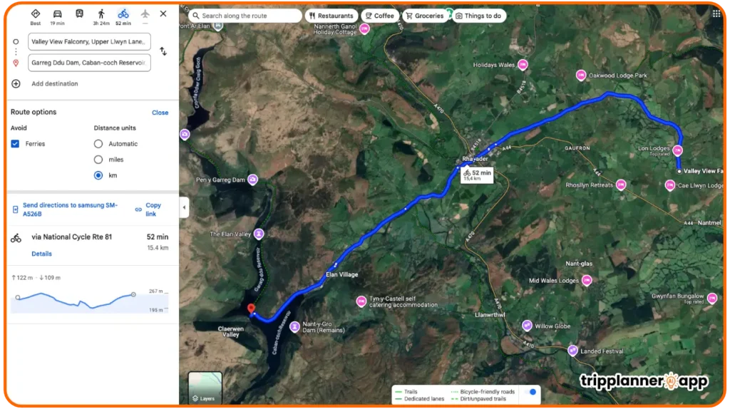
- Cycling: Cyclists can benefit immensely from elevation profiles, which help identify challenging routes with sharp inclines and descents. By viewing this data beforehand, cyclists can fine-tune their training and gear selections to suit the terrain. For instance, planning a ride through the undulating terrain of Tuscany requires knowing where efforts should be conserved for long climbs or sprints.
- Road Trips: When hitting the open road, knowing elevation changes can guide route selection. High-altitude routes offer stunning views but may demand a higher level of vehicle maintenance and acclimatization strategies for passengers. Navigators can preemptively plan rests and fuel stops according to these elevations.
- Altitude-sensitive Destinations: Some places like Machu Picchu or the Rockies present unique challenges due to their altitudes. Tourists can input these destination elevations into itinerary planners to anticipate things like altitude sickness and plan accordingly with necessary acclimatization steps.
Each of these applications spotlights the essential role that elevation data from Google Maps plays in designing travel itineraries, ensuring safe, comfortable, and rewarding experiences. By utilizing this data, travelers can prepare adequately for the demands of their journey, enhancing both safety and enjoyment.
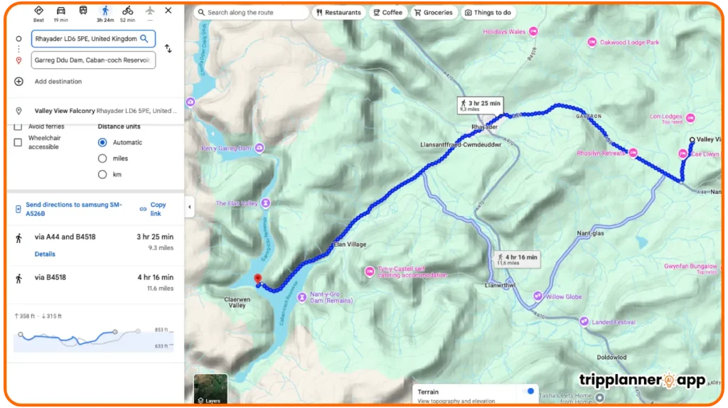
How to view elevation on Google Maps
To leverage elevation data successfully, users must first understand how to access it through Google Maps. The platform offers various ways to view elevation, depending on your device and preference for detail. You can explore the landscape in different ways, using either a desktop or mobile application, but each method comes with its own set of features and limitations.
On desktop: using terrain mode
Accessing elevation data on a desktop is straightforward and allows for a greater degree of control and detail. Here’s a step-by-step guide to viewing elevation using Terrain mode:
- Open Google Maps: Begin by navigating to maps.google.com on your desktop browser.
- Choose a Location: Search for the location you wish to explore using the search bar, then select your desired spot from the results.
- Engage Layers: At the bottom left of the screen, open the Layers menu by clicking the icon resembling a stack of boxes.
- Select Terrain: Inside the Layers menu, click on “Terrain” to activate this mode. This switches the map view to display terrain features, highlighting elevation points.
- Zoom for Detail: Use zoom controls to explore specific elevation details. At optimal zoom levels, contour lines and elevation markers will appear, providing informative insights into the topography.
This focused view effectively visualizes hills, valleys, and plateaus, all essential for planning activities such as road trips or outdoor excursions. Using Terrain mode on a desktop for accessing elevation data provides users with clarity and precision, essential for informed decision-making in travel planning.
On mobile: limitations and alternatives
While Google Maps’ mobile app provides valuable elevation data, users will encounter certain limitations compared to the desktop version. Here are key points to consider about using mobile devices:
- Terrain Visibility: On mobile, elevation data is primarily visible in mountainous areas, potentially limiting detailed knowledge in urban or flat regions. For full visibility, users must toggle the “Terrain” setting in the Layers menu within the app.
- Display Challenges: As you zoom in and out on the map, the elevation numbers might not always be visible, making it challenging to get exact figures.
- Alternatives for Precision: To overcome these limitations, users can turn to other resources like Google Earth Pro, which offers superior elevation data and profile charts.
Despite these restrictions, having elevation data on a mobile device while traveling is convenient and can still enhance trip planning. When combined with additional resources, users can achieve an effective planning strategy without missing crucial information.
How to use elevation profiles for trip planning
Once you’re familiar with accessing elevation data through Google Maps, it’s time to move on to more specific applications by creating elevation profiles. These profiles allow travelers to prepare better by analyzing altitude gains and losses, selecting routes that match their capabilities and enhancing their overall travel experience.
Hiking: plan routes by altitude gain/loss
Hiking is greatly influenced by altitude changes, and planning with elevation profiles is essential for a fulfilling and safe experience. Here’s how you can effectively use this data:
- Create an Elevation Profile: By drawing your intended path on Google Maps, you can generate an elevation profile. This profile will detail the ascent and descent across the terrain, offering insight into the hike’s difficulty.
- Identify Key Elevation Points: Use the profile to locate daunting climbs and plan rest stops accordingly. Knowing where your biggest challenges lie allows for strategic preparation.
- Match Trail to Fitness: Ensure the trail corresponds to your fitness level by comparing the elevation profile with personal stamina and acclimatization ability, especially in high-altitude environments.
Planning hikes with a focus on elevation gains and losses delivers a more tailored and enjoyable experience while minimizing unnecessary physical strain.
Cycling: identify steep climbs or safer paths
Cyclists face distinct challenges intended by elevation changes, where a detailed elevation profile can be a game-changer.
- Evaluate Elevation Gradients: By using Google Maps’ elevation information, cyclists can anticipate sharp inclines or plan for flat sections to conserve energy. Elevation gradients provided by the maps allow for the evaluation of challenging terrain.
- Route Sophistication: Experienced cyclists can challenge their limits by selecting routes with sharp elevation changes, while beginners might avoid them, opting for gentler slopes.
- Analyze Potential Risks: Be mindful of particularly steep descents that could increase brake wear or create hazardous conditions. Prepare equipment accordingly to ensure a safe journey.
By understanding elevation profiles, cyclists can optimize their routes to align with skill levels and personal objectives, whether tackling steep climbs or seeking safer paths.
Driving: mountain roads, scenic overlooks, altitude awareness
Road trips might sound straightforward, but elevation data is crucial in crafting a safer, memorable drive through scenic landscapes, especially in mountainous regions.
- Plan for Steep Climbs: Routes through mountainous terrain may offer breathtaking vistas but come with technical demands on vehicular performance. Knowing these elevation changes helps prepare for potential overheating or transmission issues.
- Identify Scenic Stops: Utilize an elevation profile to pinpoint high-altitude overlooks offering spectacular views, allowing for well-planned stops along the way.
- Awareness of Speed and Braking: Drivers must be aware of elevation-induced changes in vehicle handling, demanding careful speed adjustments and braking techniques.
Using elevation profiles for road trips through mountain roads ensures driver readiness and capitalizes on the journey’s beauty, offering both security and pleasure.
City walking tours: assess accessibility and effort
Elevation data isn’t only useful in remote or rugged landscapes it provides valuable context for city walking tours by evaluating the difficulty and accessibility of urban routes.
- Assess Slope Gradients: Certain city areas can be surprisingly hilly, especially those with distinctive topographies such as San Francisco. Understanding gradients is essential for planning accessible routes.
- Judge Timing and Effort: Use elevation information to estimate walking times and physical exertion required, customizing tours to match participants’ fitness levels.
- Choose Pathways Wisely: Avoid routes that might be too challenging for certain individuals, such as those involving lengthy, steep climbs. Opt for flatter alternatives that maintain safety and comfort.
By incorporating elevation profiles, city tours can be customized to balance effort, enjoyment, and accessibility, catering to a broader range of visitors and ensuring no traveler misses out on urban exploration.
How to combine elevation with AI-generated itineraries
The combination of elevation data from Google Maps with AI-generated itineraries offers a dynamic approach to travel planning. This integration enhances terrain awareness, ensures appropriate pace, and caters itineraries to specific fitness levels and preferences.
Add terrain awareness to your day plans
Incorporating terrain awareness into your daily itinerary ensures strategic planning that anticipates challenges and leverages opportunities to enjoy the natural environment.
- Leverage AI for Personalized Suggestions: AI can assess individual preferences and propose itinerary options that align with chosen terrains, recommending activities that suit the traveler’s endurance.
- Real-Time Feedback: As you engage in your planned activities, AI can analyze your progress and adjust suggestions on the fly, pointing you towards routes that align better with your current location and stamina.
- Consider Seasonal Impacts: AI can integrate elevation profiles with weather forecasts to advise on the best seasonal timings, reducing the likelihood of adverse conditions.
Terrain awareness fine-tuned with AI capabilities allows you to optimize day plans, ensuring they are not only enjoyable but also safe and aligned with personal preferences.
Adjust timings based on uphill vs. flat paths
The impact of elevation on travel pacing can’t be overstated. Adjusting itinerary timings based on gradients ensures accurate expectations and efficient scheduling.
- Analyze Elevation Profiles: AI tools can interpret elevation profiles to predict timing variations across uphill and flat segments, offering insight into how much time each section may require.
- Plan for Rest Stops: Factoring in breaks during steep climbs helps manage exertion and provides opportunities to admire the surroundings.
- Custom Timings for Group Travel: Different travelers possess varied endurance levels. By analyzing elevation impacts, itineraries can be adjusted to accommodate the group comfortably.
Adjusting schedules based on path inclination levels ensures a more comfortable journey, enhancing both enjoyment and effectiveness in meeting planned timetable constraints.
Feed elevation info into AI prompts (e.g., “plan a low-altitude hike near Quito”)
Incorporating elevation data into AI planning prompts can personalize and enhance travel experiences, offering activities tailored to specific altitudinal preferences.
- Personalize Prompts with Elevation Details: Commands like “find a low-altitude hike near Quito” direct AI to seek paths that align with preferences for lower elevation gains, ideal for those sensitive to altitude change.
- Maximize Comfort: Allow AI to scan elevation markers and profile changes to suggest locations that minimize discomfort due to altitude.
- Dynamic Itinerary Adjustments: As real-time data comes in, AI can re-evaluate the chosen paths, suggesting on-the-go modifications based on the latest elevation information.
AI augmentation of itineraries facilitates more precise, elevation-oriented travel planning, matching itineraries with individual needs, and transforming travel into a tailored, responsive experience.
Use elevation to evaluate fitness level suitability
Elevation data offers a distinct method for evaluating fitness suitability, determining which activities are appropriate and aligning these with personal abilities.
- Set Goals and Challenges: AI tools can utilize regular updates on elevation data to set tailored goals or challenges that align with a user’s inquiry.
- Evaluate Progress Over Time: Use evaluations to adjust difficulty, ensuring that itinerary segments meet progressive fitness milestones, maintaining motivation while actively pursuing healthier lifestyles.
- Enhance Fitness Levels: Introduce gentle challenges with minimal altitude differences to avoid discouragement, gradually increasing intensity as confidence and strength grow.
The combination of elevation insights with fitness objectives allows for the creation of dynamic, personalized plans that cater directly to pushing boundaries at a comfortable pace, ensuring each journey is an opportunity to both explore and enhance fitness outcomes.
Explore the latest posts in our AI Travel Guide to craft the best travel plans tailored for you.


Third-party tools that extend elevation use
While Google Maps provides a substantial base for elevation data, several third-party tools offer enhancements that expand upon its capabilities, providing even more detailed insights into terrain analysis and planning, particularly for specialized areas or activities.
Google Earth: 3D elevation & cross-section profiles
Google Earth surpasses many mapping tools with its robust features, allowing users to explore the world in 3D models including elevation and cross-section analyses. Here’s how it can be leveraged:
- 3D Visual Exploration: Transport yourself with Google Earth’s comprehensive 3D renderings. View mountain ranges, valleys, and plains, assessing these views for excursions and appreciating the geographical context.
- Detailed Cross-Section Profiles: Analyze paths by creating cross-section profiles that visually depict altitude variations and enable precise calculations of elevation changes concerning ascents and descents.
- KML File Integration: Use KML files to save routes for easy access to revisit planned paths and their elevation changes, sharing these across devices or with other travelers.
Google Earth provides a means to delve further into terrain characteristics, benefiting any terrain-oriented explorations or expeditions with superior data resolution.
Elevation profile viewers for GPX/KML routes
Creating and analyzing elevation profiles for planned routes, especially in GPX and KML formats, offers valuable insights into trips’ geographical features.
- Tools and Technicalities: Various software applications like GEOCONTEXT-PROFILER and QGIS enhance what Google Maps offers by allowing imports and producing elevation profiles effortlessly.
- Data Exportation: You can export elevation data into formats such as CSV for further analysis and integration, whether scheduling a hike or organizing group excursions.
- Comprehensive Route Planning: With these tools, you can better understand environmental challenges ahead and establish alternative strategies for navigation should conditions demand.
These enhanced functionalities aid users in formulating precise outdoor schedules, weighed, and adapted through exhaustive altitude data sets, advocating well-prepared voyages despite conditions.
Apps like Komoot, Strava, or AllTrails (with Google Maps integration)
For navigating the outdoors, apps such as Komoot, Strava, or AllTrails are popular choices thanks to their inclusive features and capabilities.
- Komoot: Delivers stellar route planning for both hikers and cyclists, offering turn-by-turn navigation and offline map availability. Despite some dependency on network access, its grasp on open trails and roads remains outstanding.
- Strava: A favorite among cyclists and runners, Strava mixes social engagement with performance analytics, including elevation gain data, albeit limited compared to topography-specialist tools.
- AllTrails: Housing an impressive catalog of user-generated hiking information, AllTrails furnishes its database with images and reviews. Offline maps for premium users are beneficial if navigation options become limited.
While these apps don’t provide real-time Google Maps integration for elevation, they adequately compile diverse terrain data sets, with user-defined specifics preceding their mapping functionalities. Whether trekking the mountainsides or biking through bustling trails, third-party integration encapsulates the supplementary support and added depth these platforms afford.
Limitations to consider
Despite the numerous practical applications, limitations exist within Google Maps’ elevation data, which third-party tools often address. These constraints should be understood to plan effectively and adjust expectations appropriately when relying on this digital toolset for elevation insights.
Not always available in remote areas
Elevation data availability is inconsistent, especially in isolated or less-frequented regions, posing a challenge when topographical information is most needed.
- Data Sparsity: Google Maps primarily benefits those in populated areas and familiar destinations, leaving some rural explorations with little to no data.
- Alternative Data Sets: Regions lacking thorough mapping can be difficult for those reliant on a contiguous supply of elevations and require identifying and sourcing additional mapping services.
- Impact on Planning: Reliable elevation data is critical when determining viable routes or logistical transport paths without direct visual references in remote environments.
Knowing these challenges urges travelers to prepare adequately for adventures beyond the highs and lows of digitally mapped elevations, embracing alternative press as a means to ensure an informative trekking encounter.
Contour visibility depends on zoom level
Google Maps’ capability to display elevation information relies heavily on the zoom setting at any given time, creating a sometimes hazardous scenario for users seeking specific data.
- Zoom and Detail Dynamics: Contour lines or elevation numbers may not appear or disappear at different zoom levels, which can restrict an accurate representation of terrain.
- Optimal Zooming Strategy: It’s essential to find and maintain an optimal zoom level to gain desired information, alternately using a combination of settings to secure adequate data visually.
- Balancing Overview with Detail: A balance must be struck between obtaining an overview and understanding minute details both being vital for strategic planning.
These restrictions indicate a need for meticulous attention when navigating Google Maps to retrieve elevation details, especially when seeking precision, and inform how best to integrate further platforms and strategies into comprehensive travel planning.
No real-time elevation readings without external apps
Without supplementary support from third-party applications, the ability of Google Maps to provide real-time elevation assessments falls short, conceivably influencing time-sensitive scenario analyses.
- Static Elevations: Without real-time updates, deductions rely on earlier data, potentially limiting resolution of real-time environmental shifts.
- App Synergy Potential: Here, Google Maps serves best as a backdrop upon which further applications deliver timely updates and analyses as required by journey specifics.
- Comprehensive Situational Awareness: Integrating regular, dynamically updated insights with static basemaps optimizes strategic travel oversight.
Acceptance of these constraints encourages users to incorporate alternative resources that extend Google Maps’ foundational offerings, ensuring they are equipped with current, precise information under complex or immediate decision-making junctures.
Pro tips for travelers
While limitations to Google Maps’ elevation data exist, these can be effectively mitigated with strategic planning and combined uses of tools to enhance your travel adventures, assuring comprehensive geographic comprehension for visionary itinerary mapping.
Switch between satellite, terrain, and street view for better context
One of Google Maps’ most advantageous features is the ease with which you can switch between map views to obtain a comprehensive understanding of your route.
- Satellite View: Provides bird’s-eye perspectives with real-world imagery, useful for understanding physical layouts of landscapes.
- Terrain View: Best for examining topographical characteristics like contour lines and elevation changes, vital for outdoor planning.
- Street View: Offers ground-level imagery, showing roads and paths in dynamic 360-degree views, enabling closer on-the-ground navigation focus.
Switching between these views furnishes users with complete situational awareness, ensuring their journeys align with geographical, infrastructural, and practical understanding.
Use saved maps to cross-check elevation at key waypoints
Maximizing the experience of using Google Maps entails creating and saving maps that associate significant waypoints with relevant elevation data.
- Integrate Elevation at Waypoints: Saved maps add a remarkably flexible re that can be referenced across numerous devices for continuity and cross-checking.
- Nuanced Elevation Integration: Enhance the effect by checking elevation at specific waypoints critical for navigation or strategic stops in trip planning.
- Collaborative Engagement: Sharing saved maps enables effective coordination among fellow adventurers, ensuring collective comprehension of terrain dynamics.
Strategically utilizing saved maps leverages your mobility and independence, enhancing precision in outdoor itinerary creation, aligning with geographical realities in tandem with overall tour objectives.
Combine with weather and traffic layers for full planning perspective
Integrating Google Maps with available layers can pipe in valuable insights, minimizing surprises and amplifying travel efficiency and enjoyment.
- Weather Awareness: While not directly available through Google Maps, adjacent weather apps allow forecasting pertinent to routes, offering significant planning re.
- Traffic Insights: Navigate high-congestion zones efficiently with traffic data, planning timing and route course meticulously over colored-coded indicators.
- Elevation and Interpretation: Conjunctive understanding of road elevation and related conditions supports broad-scale planning efforts poised for optimum results.
Together, these tools offer a powerful confluence of data, enriching travel preparation with a complete view covering elevation, traffic, and weather circumstances aligned towards superior strategic travel foresight.
Final Thoughts
Mapping the world around us is as much an exercise in understanding as it offers an exploration of our senses. Google Maps extends a gateway to untold adventures, connecting us more deeply with landscapes and spaces beyond purely rudimentary paths. Its elevation data adds dimension to our visions and journey comprehension, offering invitations to explore from the comfort of digital simulations, stretching our appreciation of our Earth.
Let us not see these static digital outlines as limitations, but mere beginnings to our fullest sense of exploration. The challenges presented by terrain signals nature’s welcome mat, demanding careful preparation, respect for its processes and a willingness to adapt. As we embrace technology’s burgeoning role in our discoveries, even greater collaborative technological flourishes, like AI, elevate our experiences and literate our landscape navigation that guides us safely and adventurously through 21st-century life. As we seek to harmonize nature and technology, mapping not only finds inroads but connects us back to the landscapes that cradle our world, promising journeys worth every mile.
Through integration and insight, we prepare. So plan with heart, approach with mind, undertake with spirit and keep an eye ritually open, charting not just paths but journeys unforgettable.