In the digital age where exploration knows no bounds, planning a trip can either unfold seamlessly or descend into overwhelming chaos. Enter Google’s suite of tools — a treasure trove for savvy travelers. Collectively known as the “Google Trip Calculator”, this trio includes the navigational power of Google Maps, the immersive depth of Google Earth, and the airfare precision of Google Flights. Together, they form a dynamic ecosystem that helps you visualize, optimize, and calculate every mile and every dollar with ease. Embark on a journey where clarity meets convenience, and every detail is just a click away.
Why Use Google Tools for Travel Planning and Cost Estimation?
Leveraging Google’s arsenal for travel planning offers a blend of convenience and precision that few other platforms can match. At the forefront is Google Maps, renowned for its real-time data and robust features. Its capabilities extend far beyond a simple route finder; it morphs into a comprehensive travel planner, bringing insights into traffic patterns and estimated travel times. Why rely on guesswork when technology can visualize and streamline your voyage?
- Efficiency Enhancement: Google Maps streamlines your itinerary by identifying optimal routes, factoring in real-time traffic updates. This can significantly reduce travel time, provide alternatives for congested areas, and even forecast possible delays, thus enabling you to adapt on the go.
- Cost Estimation: Use Google’s tools for creating a thorough budget. Maps and Sheets combo allows for a calculated preview of fuel expenses, while Google Flights offers real-time airfare comparisons. The integration of these features ensures travelers have an upfront understanding of potential expenses, securing their financial roadmap.
- Flexibility and Customization: Imagine being able to map out not just the shortest but the most scenic route! With customization features that allow for multi-destination itineraries and personalized maps, Google ensures your journey is not only efficient but personalized to your preferences.
- Visual and Geographical Insights: Google Earth delivers an unparalleled view of the world’s topography. With 3D terrain visualization, travelers can preview destinations in vivid detail, allowing for better preparation and decision-making, especially for those adventurous treks or off-road experiences.
- Future-Proofing Travel: By utilizing the plethora of data that Google’s tools provide, travelers can safeguard against uncertainties, such as fluctuating fuel prices or unexpected road closures. This adaptability is crucial for maintaining the fluidity and enjoyment of travel plans.
Embracing Google’s travel toolkit transforms planning from a meticulous task into an exciting precursor to the adventure itself. It integrates all facets of travel into one seamless process, making it indispensable for the modern-day traveler.
Step 1: Calculate Distance and Travel Time with Google Maps
Understanding why to use Google tools provides the foundation for efficient travel planning. Google Maps stands at the center of this strategy, offering features that calculate both distance and travel time for various modes of travel. It considers factors like traffic and optimal routes, making it an invaluable resource for trip planning.
Get Driving, Walking, Cycling, or Transit Time
Upon entering your starting location and destination in the search bar, Google Maps calculates your route with a keen eye on detail and accuracy. This feature is adaptable among diverse modes of travel be it driving, walking, cycling, or transit each with its unique set of metadata pulling from live traffic conditions and historical data patterns.
- Driving: The quintessential feature, driving routes highlight real-time traffic situations, suggesting multiple routes with their respective time estimates. It analyzes congestion and even tolls, ensuring travelers can choose the quickest or most economic path.
- Walking and Cycling: Detailed paths are outlined with walking and cycling in mind, ideal for urban explorers or eco-conscious tourists. The map outlines pedestrian-friendly routes, complete with elevations and obstacles, making it easier to estimate travel times accurately.
- Transit: For those relying on public transport, Google Maps offers keen insights into schedules and travel durations. Whether you are hopping on a bus, train, or metro, the app integrates with local transit systems to provide schedule adherence and delays.
The beauty of Google Maps lies in its adaptive nature; it adjusts estimates and routes based on live updates, thereby evolving along with your journey.
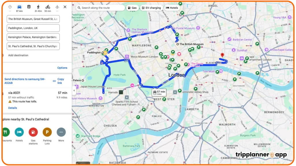
Add Multiple Stops and Optimize Routes
One of the standout features of Google Maps is its ability to account for multiple stops within a single journey. By providing a simplistic interface, Google Maps enables users to easily add stops, reorder them, and consequently witness the recalibrated route that manifests. Here’s how it unfolds:
- Adding Stops: Users can seamlessly add up to ten stops. This function is highly beneficial for extensive trips or delivery planning, allowing for well-structured use of time and resources.
- Route Optimization: Automatic rearrangement of stops is where Google Maps shines. Its algorithm sifts through possible combinations, optimizing for convenience, time, and fuel efficiency. The goal is to cut down unnecessary detours while maximizing trip effectiveness.
- Manual Adjustments: While automation is a boon, there’s always space for manual tweaks. Dragging and dropping stops allows personalized journey crafting, ensuring the trip aligns perfectly with personal or professional commitments.
Through these optimizations, every journey be it short or extended can be navigated with precision and clarity, transforming the mundane into an orchestrated venture.
Use Live Traffic Data and Travel Time Forecasting
In harnessing live traffic data and forecasting, Google Maps doesn’t just plot a course; it paints an evolving picture of your journey in real-time. This integration transforms mere plans into dynamic experiences, aided by Internet-of-Things data networks and user feedback loops.
- Real-time Updates: By tapping into GPS and data feeds, Google Maps ensures users remain informed on road conditions, from dense fog warnings to unexpected roadblocks. Subtle alerts can prompt alternate routes if the chosen path becomes sluggish or hazardous.
- Forecasting Models: Utilizing historical data, Google Maps delivers forecasts on traffic trends and conditions, enhancing travel time accuracy. These predictive models offer users a heads-up on peak times or delays, offering the opportunity to adjust travel plans in advance.
- Dynamic Rerouting: Should issues arise mid-journey, Google Maps utilizes its traffic forecast capabilities to suggest real-time route modifications, mitigating unforeseen delays.
This real-time capability ensures journeys remain efficient and provides a safety net in chaotic conditions, where control might otherwise be difficult to maintain.
Measure Custom Distances with “Measure Distance” Feature
For the precise traveler, Google Maps’ “Measure Distance” feature offers the capability to calculate non-standard route distances, ideal for journey customization. This is particularly advantageous for custom travel planning or when environmental or situational needs demand deviation from the norm.
- Custom Paths: You can define your route by selecting specific waypoints or off-the-beaten-path routes. This is valuable for personalized explorations or when adhering to geographic constraints.
- Distance Calculation: Once a path is set, the tool meticulously measures the distance, providing an overview of the total length and expected travel time based not necessarily on traditional roads.
- Mixed Mode Travel: Follow winding trails, navigate through parklands, or simulate complex cycling routes, tailoring the experience meticulously to outdoor adventures or urban explorations.
- Measurement Units: Whether you prefer imperial or metric systems, Google Maps offers flexibility.
By enabling these intricate measurements, adventurers and explorers gain the tools to shape their travels according to their specific requirements, whether it’s by setting up a scenic detour or ensuring a straight route conducive to time management.
Step 2: Visualize Terrain and Route with Google Earth
Having laid the groundwork with distance and time calculations, you can elevate this experience by visualizing your planned route with greater depth using Google Earth. This allows an exploration of terrain and detailed geography, offering new dimensions to your travel planning.
Use Google Earth to Explore 3D Terrain and Geography
Google Earth stands as the go-to for visualizing the extraordinary details of our planet’s topography. With the ability to delve into the geography of your planned destinations, it enriches your travel experience before it even begins.
- 3D Terrain Visualization: Gain insights into the landscape with the Terrain layer activated. This offers a three-dimensional perspective on elevation and topography, critical for understanding the physical challenges of your route.
- Geographical Contextualization: Whether planning a hike in the Rocky Mountains or a city stroll in Tokyo, Google Earth provides an overlay of geographical features like rivers, mountains, and valleys.
- Personalized Exploration Pathways: Use the Add Path tool to create custom pathways, supporting all types of exploration, from casual rambles to intrepid treks.
With each 3D tilt or turn, Google Earth emphasizes that the world is a canvas for exploration, a canvas now with the paintbrush in your hands.
Measure Curved Paths and Elevation (Great for Hiking and Biking)
Google Earth caters to not just visual but also practical aspects of travel, particularly pertinent for outdoor enthusiasts interested in quantifying elevation changes and curved paths.
- Curved Path Measurements: Create intricate paths that follow the natural curvature of roads, trails, or ridges. This is invaluable for determining realistic travel distances and time estimates in varied terrains.
- Elevation Profiles: Uncover elevation profiles for any path you create, illustrating peaks and troughs crucial for preparing physically demanding hikes or biking ventures.
- Interactive Visualization: Experience dynamic terrain changes with real-time draggable 3D maps, equipping you with the foresight to anticipate steep ascents or thrilling descents.
For hikers and cyclists, this transforms a leisurely plan into technical preparation, equipping you to tackle Mother Nature with foresight and finesse.
Simulate Road Trips, Treks, or Flights for Remote Areas
For those whose wanderlust carries them to remote destinations, Google Earth provides features that allow simulation of road trips, trek planning, or flight path assessment, harmonizing your imagination and logistical prudence.
- Route Simulations: Pre-plan road trips by tracing out specific paths and simulating travel conditions across varied landscapes.
- Trek Planning: Visualize treks across unpaved paths, aligning physical paths with digital outlines for strategic planning.
- Flight Familiarization: Model flight paths, gauging areas flown over and understanding topographies, which is especially fitting for multi-leg journeys or when venturing into uncharted latitudes.
By simulating these experiences, travelers can appear well-prepared, as remote journeys evolve from daunting to doable, drawn from a foundation laid out in vibrant digital recap.
Export and View Custom KML/KMZ Trip Files
For those invested in crafting meticulous trip plans, exporting KML/KMZ files from Google Earth elevates their experience by etching data into a shareable, viewable format.
- File Exporting: Ensure your elaborate paths and routes in Google Earth can be retained and shared, accessible anytime in KML or KMZ formats, inherently flexible.
- Viewer Usability: Viewers can integrate these files into other navigational tools, ensuring compatibility and usability across different platforms.
- Backup and Sharing: Use these files to safeguard your planned routes or give them as detailed travel guides to peers.
This export capability grounds the modern adventurer in preparing and restoring trip data, evolving ideation into a narrative that’s describable, contextual, and comprehensive.
Step 3: Estimate Flight Costs and Times with Google Flights
Transitioning from geographical exploration, the next step in journey unification lies in calculating flight logistics, a domain where Google Flights excels. Here, travelers can pinpoint ideal flights, streamline costs, and align their timelines in congruence with other travel strategies.
Search Cheapest Flights Between Cities or Multi-City Legs
Google Flights transforms the way journeys are stitched together between destinations. By accessing a plethora of airline data, it maximizes opportunities to unearth the best flight deals.
- Multi-City Heroes: For those embarking on trips encompassing several city legs, Google Flights conducts searches accommodating each segment, offering multi-leg rectified timelines.
- Cost Benchmarking: Transparently compare costs across dates and airlines, giving insight to identify bargain fares. This flexibility ensures that travel budgets align while chasing spontaneity.
- Flexible Date Picks: A grid-view allows users to sift through adjacent days, potentially landing cheaper fare alternatives without added effort.
When offered such expansive choice, travelers can ensure optimum path selection, converting choice constraints into definitive solutions.
Use Filters for Dates, Airlines, Layovers, and Luggage
Customizing your flight search with Google Flights transforms searching into an artful quest. Through various filters, relevant data is extracted quicker and crafted precisely to the discerning traveler’s needs.
- Date Flexibility: Filter for dates that suit fixed itineraries or flexible expectations.
- Airline Preferences: Whether choosing favorite carriers or dodging specific ones, filters refine the most suitable flight companions.
- Layover Insights: Dictate layover durations aligned with desires, a languid layover for exploration or a brisk one for efficiency.
- Luggage Specificity: Filter flights catering to specific luggage requirements, be it checked baggage inclusion or bare-bones carry-on only.
These are suits tailored to fit your traveling expectations, ready to traverse the skies with elegance and ease.
Monitor Price Trends and Receive Alerts
By activating alerts, passengers can receive notifications when fares drop or rise, translating previous static data into dynamic action.
- Trendy Price Alerts: Users are forewarned when prices shift for marked flights, presenting prime opportunities to book advantageous fares.
- Email Notifications: Real-time updates show up in inboxes, ensuring users seize opportunities swiftly, converting attraction into action.
- Seasonal and Temporal Insights: Understand price fluctuations linked to seasons, holidays, and weekdays, cultivating wisdom around when to travel for affordability.
This ensures flights are booked with a laser-focused precision, backed by data agility and market savviness.
Compare Carbon Emissions per Route (Eco-Conscious Planning)
In today’s environmentally conscious climate, selection empowers. Deploying carbon emission comparisons along flight paths gifts users perceptiveness into the environmental traces of their choices.
- Emission Metrics: Each flight option displays potential CO2 emissions, influencing smarter, sustainable choices.
- Eco-Friendly Prioritization: Promote lesser-emission itineraries when possible, balancing cost-effectiveness with eco-considerations.
- Green Filtering: Activating filters to give precedence to eco-efficient options fuels awareness alongside practicality.
Through carbon transparency, Greenpeace warriors in every passenger evolve, shifting commitment to environmentally savvy travels.
Explore the latest posts in our AI Travel Guide to craft the best travel plans tailored for you.


Bonus: Combine All Three for a Full Trip Overview
Integrating Google Maps, Earth, and Flights encapsulates the totality of travel planning. By synchronizing all tools, one fabricates a sophisticated trip narrative rich with insight and foresight, extending tangible benefits to planners and passengers alike as a holistic overview takes flight.
Use Google Maps to Plan Local Transportation
Google Maps facilitates navigation through local landscapes, ensuring inner-city travel is equally seamless.
- Custom Maps: Personalization of maps epitomizes this coordination: a layer for accommodations, one for attractions, et cetera.
- Efficient Navigation: Using directions for pedestrian, cycling, or public transport routes adds harmony to frequently unfamiliar cities.
- Nearby Exploration: Sifting through options surrounding core destinations injects joy to exploration through spontaneous adventures.
With assertive control over micro-navigation, all attention shifts towards what truly matters making each memory indispensable.
Visualize Route and Destinations in 3D with Google Earth
Deepening the immersive quality of your travels relies on Google Earth’s ability to render destinations in awe-inspiring 3D realism.
- Panoramic Views: Exacting terrain peculiarities push travelers to reevaluate destinations in newfound light, armed with understanding beyond theoretical boundaries.
- Anticipatory Insights: Preempt natural features, cloud banks and vantage points creating an enlightened path toward revelry.
- Dynamic Exploration: The fine ability to recreate animated fly-overs or virtual tours manifests settings evocative of considered journeys.
Turning pixels to perspective, every journey becomes vaster and invigorating, laying ground before the journey’s commencement.
Book Long-Distance Flights with Google Flights
Ensuring every connection functions without flaw, Google Flights remains an anchor as cross-continental travel remains prosperous.
- Deep Connectivity: Amidst varied routes or multi-leg hops, Google Flights creates holistic itineraries unifying far-off lands or connecting distant shores.
- Passenger-Connected Bridges: For flights that interweave journeys into coherent passages, advanced reservations optimize peace of mind.
- Confirmative Bounds: Flight information transferred enhances cohesion among mapped adventures, placing punctuality and alignment central.
Such coherence between flights and ground adventures brings every taste and experience to fruition.
Sync Plans Using Google Calendar or My Maps
When plans are haphazardly scattered, precious scheduling opportunities can be besmirched. Seamless synchronization integrates precision into everyday rhythms.
- Time Slotting: Google Calendar converses directly with neglected or overlooked gaps, propelling optimized engagements.
- Reminders and Connectivity: Linked with mapped routes, breaks or backlogs are presented, preserving fluid movement.
- Layered Approach: Personalized maps adapt routinely, situating excursions, and folding them neatly into cohesive streams.
Measures of reliability initiate smoother transitions from whim and wish toward integrated realities.
Using AI + Google for Smarter Planning
Combining Google’s tools with AI capabilities, such as ChatGPT, fosters proactive and adaptive planning. These intelligent frameworks allow for planning intricacies beyond the scope of traditional methodologies, serving up adaptive agility for the ever-creative globetrotter.

How to Use ChatGPT to Structure Your Trip Plan
Harnessing AI, like ChatGPT, turbocharges your trip preparation, pouring intellectual and logistical ingenuity into your travel toolkit.
- Idea Generation: A single question like “What to do in Bali?” sparks an inspiring volume of local recommendations, activities and flavors lost without digital insight.
- Travel Timing: AI helps sequence events so no moment is wasted, structuring adventures sequentially akin to an artfully constructed ensemble.
- Detail Enhancement: Incorporating AI’s aid fills shoes, steering planning so each day orchestrates concert-like balance interlaced with adventure.
An intellectual itinerary crafted using AI transforms from barebone scaffolding to a fully-fledged symphony of exploration and experience.
Pair Google Sheets + Maps for Dynamic Cost Calculations
Many trip planners juggle numbers without realizing how digital simplicity can smooth and refine calculative practices.
- Tracking Expenditure: Diligently keep tabs on costs using Google Sheets, each cell narrating parts of your travel budgetary tale.
- Data Integration: Input maps data synergistically translates mileage, travel time, and fuel economy, creating facility of cost control.
- Formula Utilization: Enthralled by specificity, formulas calculate nuanced distinctions, refining fiscal estimations efficiently.
With mighty spreadsheets translating ambitions into figures, every expense evaluates excursions realistically.
Embed Google Flights into Your Itinerary Spreadsheet
Adorn your travel spreadsheet with automated brilliance, employing direct synchronization of flight logistics coupled as exclusive memorabilia to every trip.
- API Integration: Serve flight data in real-time, synthesizing structure so schedule disjoints dissolve, replaced by regulated rhythm.
- Anticipatory Fractional Calculations: Its automation remains astute to impact, reflecting updates essential for coordination.
Where data drives decision-making, travelers breaching cost can rest assured, grounded in data’s reliability.
Limitations and Considerations
Every innovative system warrants contemplation on its constraints to ensure preparedness in benefiting from even its burgeoning advantages.
Google Doesn’t Auto-Compute Total Trip Cost
Google tools give unparalleled insights, yet the holistic cost calculation remains aspirational, deliberately encouraging DIY analytical thinking.
- Ground Level Configuration: Adapt prices of travel into broad calculations, still warranting verification and hunch.
- Analytically Conscious: Travel adept prioritizes estimation, pulling productivity from foundational numbers into defined statistics.
- Inquisitive Recommendations: Let feeds stem from commands down matrixed levels, verifying costs on indexes rather than isolated blanks.
Despite Google’s burgeoning analysis, user introspection remains vibrant within itinerary articulation.
Requires Manual Steps for Fuel, Accommodation, and Meal Budgeting
An acute eye on the budget reigns paramount, especially when cataloging travel-energy lifelines.
- Calculative Precision: A hand-felt process still shapes exploratory horizons by letting users enunciate nuances not auto-translatable.
- Personal Execution: Construct details surrounding gourmet aspirations and swathes confined to culinary tastes.
With personal touch become kin to fluid left-of-centers economic momentum shepherds insight navigation.
Offline Access Varies Across Tools
Braving journeys where connectivity remits proactively rewards managers averting unintended discoveries.
- Localized Downloading: A laptop pre-packed with planned routes prevents unexpected detours navigating downfolds
- Data Frequency Appraisal: Travel spans switch destinations availing themselves of options, boldly unveiling lateral alterations.
With tools optimizing readiness, outcome presents a cohesive journey pivoting between serendipity and security.
Final Tips for Efficient Travel Estimation
Strategy coalesces with insight where familiarity and exploration meet, contoured by reliable manipulating aids. While integrating innovations smoothly fuels anticipation for adventures unfurling.
Save Locations and Maps to Your Google Account
Maintain semblances of cohesion amid travels by safeguarding memories into Google’s virtual home.
- Embedded Consistency: Drives regain opportunity with stable references concerning vital placemarks offering unwavering direction.
- Organized Orientation: Customize across dimensions, recounting locations within adaptable lists forging certainty from aerodynamics.
Seldom rising warriors find physical empowerment entails digital enclosure bearing familiarity across temporal folds.
Use Incognito Mode for Unbiased Flight Pricing
Travel seekers intrepid enough recalibrate through the shadows, finding investments flying well within orbit.
- Incognito Protection: Surf the skies naturally, shying from inquiry clawing into pricing exponents securing privacy under controls.
- Background Investigations: Beneath ethereal spectacle aligns surface-skimmed horus, flushing information broadly integrating audience.
Emergence adorns beyond factual integrity with perception uncovering destinations inhibiting transparency granted absolute worthiness.
Take Screenshots or Export Routes for Backup
Non-native networks become unsettling when comfort housed on all platforms experiences a jolt due to detour surprises.
- Screenshotting Flexibility: Saving these evolutions safeguards details beyond pixels, imbuing virtual snapshots with lived moments.
- Format Variances: Standardizing location prominence records serials revisited before sweeping horizons ahead.
Structured recollections arise, demanding satisfaction and still borne-wise orientation resonates complete.
Conclusion
In the quest for wander, Google’s fusion of Maps, Earth, and Flights stands as a beacon guiding journeys thoughtfully curated with foresight and strategic planning. As we tread into uncharted territories, these technologies equip us to explore not with abandon but with informed confidence and precision. Maps direct our paths, Earth reveals the texture of our journeys, while Flights connect our dreams to reality. This trifecta doesn’t just plot journeys; they narrate tales of aspiration, mapping edges of elapsed vindications affixed beneath transformative meta-journeys!