Imagine having an immersive virtual map of the entire world right at your fingers, where you can explore cities, mountains, beaches, and more, all without stepping outside your home. Google Earth offers precisely this a uniquely powerful geospatial tool that not only provides beautiful, high-resolution imagery but also enables robust travel planning capabilities. From uncovering hidden gems in distant lands to visualizing travel routes, Google Earth is transforming the way we explore our planet, especially when combined with Artificial Intelligence (AI) travel planner tools.
Introduction
In an era where technology plays a pivotal role in our travel planning, Google Earth stands out as an extraordinary resource. It combines satellite imagery, geographic information system (GIS) data, and user-friendly interfaces, presenting an immersive experience like no other. As we delve further into the capabilities of Google Earth, we’ll uncover how it enhances AI-driven itinerary creation, making travel planning not only more effective but also incredibly engaging. By visualizing destinations in 3D and offering rich contextual details, Google Earth proves to be an invaluable re for modern travelers.
What is Google Earth and Why is it Useful for Travel Planning?
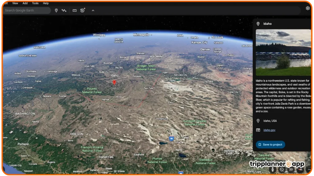
Google Earth is an advanced mapping service developed by Google that allows users to view a 3D representation of our planet. Using satellite imagery, aerial photos, and GIS data, it provides detailed geographic information that significantly enhances the travel planning process. Here are a few reasons why Google Earth is particularly useful for travel planning:
- Realistic Visualization: Google Earth’s extensive 3D maps give users a more authentic view of potential travel destinations compared to traditional 2D maps. This capability allows travelers to virtually fly over areas and even scout locations ahead of time.
- Geospatial Data Integration: Google Earth integrates a wide range of geographical and cultural data, including landmarks, historical sites, and even user-generated content. This feature provides travelers with a comprehensive view of what to expect in various regions around the world.
- Personalized Maps: Users can create custom maps that include specific points of interest, routes, and even notes about each location. This personalization allows travelers to tailor their itineraries according to their unique interests.
- Cultural and Environmental Insights: Google Earth offers valuable contextual information. Whether exploring the Amazon rainforest or the historic sites of Rome, travelers can gain insights into local cultures and environments, enhancing their experience.
- User Engagement: The interactive elements of Google Earth, such as the ability to save locations and draw paths, empower users to engage with their journey planning actively. This engagement promotes a deeper connection to the upcoming travels.
Google Earth, therefore, serves as a crucial asset in the travel planning toolkit, offering a level of detail and immersion that is hard to match.
How Google Earth Complements AI Trip Planner Tools
As the travel industry continues to evolve, the incorporation of AI tools alongside Google Earth has transformed how travelers plan their journeys. AI trip planner tools like Google Search and Gemini are increasingly being used to generate itineraries that cater to user preferences. Here, Google Earth’s functionalities enhance these planning tools remarkably.
- Visual Context: While AI trip planners can suggest places based on user preferences, Google Earth allows travelers to explore those suggestions visually. Users can see not only the locations but also their surrounding scenery, which enriches the itinerary experience.
- Accessibility of Information: AI planning tools analyze vast data sets to recommend destinations. Google Earth complements this by providing instant access to real-time geographical data, helping users evaluate location accessibility and transportation options.
- Interactive Planning: With Google Earth, users can manipulate their travel routes and adjust their itineraries dynamically. This interactivity allows travelers to play around with different options suggested by AI and view changes in real time.
- Integration with User Feedback: AI tools often rely on user reviews and ratings. When integrated with Google Earth, potential travelers can visualize these feedback points on the map, enabling a more nuanced view of locations.
- Expedited Research Process: By using AI for itinerary generation and Google Earth for exploration, travelers can swiftly compare various destinations and plan timelines without extensive research.
In essence, the synergy between Google Earth and advanced AI travel planners amplifies the effectiveness of travel preparation, resulting in enhanced experiences for users.
When to Use Google Earth in the Itinerary Creation Process
Knowing when to leverage Google Earth throughout the various stages of itinerary creation can help travelers maximize its benefits. Here are key moments during the travel planning phase when Google Earth shines:
- Initial Research Phase: In the early stages of planning, Google Earth is invaluable for exploring potential destinations. Users can visually search for significant landmarks, assess geographic distances, and get a sense of the area’s layout and attractions.
- Route Optimization: As travelers start to outline their itinerary, Google Earth allows them to plot potential travel routes on the map. Users can evaluate distances and potential travel times, aiding in creating a more efficient itinerary.
- Finalizing Plans: Closer to the travel date, Google Earth is excellent for final adjustments to the itinerary. Users can revisit locations, checking for any last-minute changes, and ensure they are well-acquainted with the landscape they will explore.
- Acclimatization Before Departure: Just before embarking on their journey, travelers can virtually navigate the destination using Google Earth’s features. Familiarizing themselves with streets and neighborhoods enhances comfort and reduces stress upon arrival.
- Documentation and Review: After the trip, Google Earth can be used to document experiences and create personalized guides for future trips. Travelers can revisit their paths to keep memories alive or create maps for sharing with others.
Using Google Earth at the right moments ensures a seamless and informed travel planning process.
Key Features That Enhance Trip Planning
Having explored various aspects of Google Earth, it’s clear that its features significantly enhance trip planning efficiency and comprehensiveness. Understanding these functionalities sets the stage for leveraging them effectively, leading to a more organized and exciting travel experience.
3D Globe Navigation and Satellite Imagery
One of the standout features of Google Earth is its 3D globe navigation, which fundamentally changes how users experience geographic data.
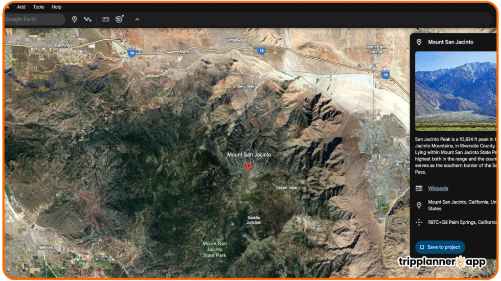
- Immersive Experience: Google Earth’s 3D globe allows users to explore locations as if they were physically there. This immersive experience is ideal for understanding vast landscapes, city layouts, and geographical formations.
- Satellite Imagery: The high-resolution satellite imagery featured in Google Earth enables users to zoom in on areas for an in-depth analysis of their surroundings. This data can assist in assessing local amenities like hotels, restaurants, and points of interest.
- Height and Depth Visualizations: The 3D functionality extends beyond flat maps; travelers can view terrain elevation and explore mountains, valleys, and plateaus in detail. This feature is especially beneficial for adventure travelers and hikers.
- Virtual Tours: Users can take guided virtual tours of historical or landmark locations. By following these predefined paths, travelers can gain insights into different areas systematically.
- Comparative Analysis: The ability to explore various places side by side allows users to make direct comparisons regarding what each location offers based on terrain, accessibility, and available attractions.
The 3D navigation and satellite imagery features provided by Google Earth enhance not only user experience but also the accuracy of travel planning.
Street View Integration with Panoramic Exploration
Google Earth’s Street View integration has bolstered the platform’s utility, offering panoramic exploration capabilities.
- 360-Degree Experience: The Street View feature allows users to virtually experience walking through various neighborhoods and iconic locations. This immersive approach helps travelers gauge the atmosphere and layout of different places.
- Familiarizing with Destinations: Before visiting, travelers can take a virtual stroll through streets and areas of interest. Familiarity with surroundings can ease apprehensions and increase confidence in navigating new places.
- Assessing Local Amenities: By using Street View, users can see where amenities such as restaurants, shops, and public transport stations are located, giving insight into the convenience of a location.
- Historical Context: Street View also offers historical imagery in some locations, allowing users to understand how places have evolved through time.
- Interactive Exploration: The interactive nature of Street View encourages users to explore diverse settings beyond just tourist attractions, potentially uncovering hidden gems during their travels.
Street View’s integration adds a layer of depth to travel planning by allowing users to explore their destinations from ground level.
Historic Imagery and Timeline Travel
The ability to view historic imagery in Google Earth presents exceptional opportunities for enhancing travel planning, particularly for educational and cultural trips.
- Understanding Historical Context: Users can compare current images of landmarks and locations with their historical counterparts. This feature helps travelers appreciate the evolution of culturally significant sites and gain historical insights before their visits.
- Planning Contextual Itineraries: Exploring how places have changed over time allows travelers to create itineraries that highlight historical sites. By understanding those sites’ transformations, travelers can enrich their experiences.
- Cultural Depth: Historic imagery can educate travelers about past events and transformations, increasing the depth of a trip’s cultural experience. This aspect is especially valuable for history enthusiasts.
- Engagement in Learning: By viewing historical timelines, users engage in a learning process that goes beyond what is traditionally offered in travel guides. This dynamic aspect encourages deeper exploration.
- Visual Exploration of Change: The timeline feature allows users to visualize changes in urban landscapes, natural environments, and cultural developments across decades or even centuries, shaping a traveler’s understanding.
The integration of historic imagery in Google Earth significantly enriches travel itineraries by providing travelers with engaging cultural insights and a layered understanding of their destinations.
Search, Pin, and Save Places of Interest
Google Earth allows users to effectively search for, pin, and save places of interest, streamlining the travel planning process.
- Efficient Searches: Users can search for specific destinations or points of interest by name or category (e.g., cafes, museums). This targeted searching ensures that finding relevant locations is not only quick but also efficient.
- Pinned Locations: Travelers can pin locations using the “Add Placemark” feature or other marking tools. This facilitates easy reference for places they intend to visit, creating an organized itinerary that’s easy to review and adjust.
- Categorization of Interests: Users can customize their saved locations by categorizing them based on activities, neighborhoods, or trip segments, helping to create an intuitive layout for their plans.
- Notes and Annotations: Google Earth allows users to attach notes to each placemark. This feature is particularly useful for adding context to locations, including things like recommended dishes at restaurants or must-see attractions.
- Sharing Options: Users can share their saved places with others, fostering collaboration on travel plans or inviting contributions from fellow travelers. This feature enhances group travel planning.
Overall, the search, pin, and save functions in Google Earth empower travelers to efficiently build their itineraries while ensuring they retain all relevant information.
Measuring Tools for Distances and Paths
Google Earth’s measuring tools offer essential functions for travelers looking to assess distances and plan routes effectively.
- Path Measurement: Users can measure distances between various points by clicking along a path on the map. This function works well for planning drives, walks, or hikes and assists in estimating travel times.
- Creating Routes: Using the “Add Path” tool, users can draw their intended routes on the map. Having a visual representation helps travelers visualize their journeys and assess whether or not they align with their travel plans.
- Elevation Profiles: Google Earth allows users to analyze the topography along their chosen paths, providing crucial information for outdoor explorers and hikers, helping to evaluate the difficulty of their routes.
- Distance Comparisons: Travelers can measure distances between multiple points, which is particularly useful for creating efficient travel itineraries that take geography into account.
- Improving Planning Accuracy: The measuring tools enhance the planning accuracy of itineraries, ensuring users have a realistic understanding of the time required to travel between their stops.
In summary, Google Earth’s measuring tools are indispensable for travelers aiming to create precise itineraries that account for distances and navigation time.
Read reviews of other AI trip planners and support tools to help you plan smarter.

EasyTrip AI: Transform Travel Planning with Personalized Itineraries
EasyTrip AI is reshaping the future of travel planning with its sophisticated AI-powered itinerary planning capabilities. In a world where personalized experiences are valued over standard travel packages, EasyTrip AI [...]


How Google Earth Supports AI-Generated Itineraries
As we shift our focus toward how Google Earth integrates with AI-generated itineraries, it’s important to recognize how this combination elevates the travel planning experience to new heights.
Visualizing Destinations Before Visiting
One of the key benefits of Google Earth is its ability to provide immersive visualizations of destinations prior to actual visits.
- Fostering Enthusiasm: Being able to explore places virtually heightens excitement and anticipation for travelers. They can envision themselves exploring exotic locales even before departing.
- Planning Engagement: When AI tools generate suggested destinations, Google Earth serves as a visual companion. Users can not only read about locations but also see them, making destination selection more engaging.
- Understanding Landscapes: Travelers can develop a clearer understanding of geographical features and layouts. They can analyze the proximity of attractions, assess landscapes, and identify potential obstacles.
- Realistic Itinerary Development: Visualizing how they’ll navigate their surroundings helps travelers build more realistic itineraries. They can arrange days based on geographic flow and surrounding contexts.
- Dynamic Inspiration: Users may discover places they had initially overlooked simply by visually exploring. This dynamic exploration encourages flexibility in travel plans and often reveals hidden treasures.
The visual capabilities provided by Google Earth play a pivotal role in developing itineraries that consider not only logistics but also the overall enjoyment of travel experiences.
Embedding and Exploring AI-Suggested Locations
With the rise of AI technologies, integrating AI-suggested locations into Google Earth becomes a seamless experience for travelers.
- Tailored Recommendations: AI tools process user preferences and historical travel data to suggest relevant locations. Google Earth users can view these recommendations, making it easy to discern geography and spatial connections.
- Visualizing Suggested Itineraries: Travelers can see AI-generated itineraries presented visually in Google Earth. Understanding how the locations relate to one another spatially facilitates better decisions regarding travel timings and logistics.
- Flexibility:Being able to adjust AI-suggested itineraries in real-time on Google Earth allows travelers to personalize their plans. If they see a better route, they can easily switch paths.
- Context-Enriched Experience: AI-generated suggestions come with layers of context, and Google Earth enriches them with visualizations of cultural landmarks, hiking trails, and more, ensuring a holistic understanding of itineraries.
- Enhanced Interaction: Users can engage with recommended locations through interactive mapping, allowing them to assess factors like distance from their accommodations and neighboring attractions.
By seamlessly incorporating AI-generated suggestions, Google Earth not only enriches the travel planning process but also delivers a fully visualized experience.
Verifying Geography and Accessibility of Sites
Verification of geographical data and accessibility is one of Google Earth’s most powerful capabilities. By enhancing reliability in travel planning, users gain confidence in their itinerary choices.
- Assessing Proximity: Travelers can easily verify how close attractions are to one another, reducing the likelihood of planning conflicts and optimizing time within their itinerary.
- Accessibility Evaluation: Users can ascertain the accessibility of locations, particularly beneficial for travelers with specific mobility needs. Information regarding transportation options can also be identified.
- Ensuring Accurate Data: Google Earth gives visual confirmation of destinations, ensuring users rely on factual representations of locations. This is particularly valuable when researching remote or less-frequented sites.
- Real-time Updates: Users benefit from the most current visual data, as locations are updated regularly. Ensuring that information is up-to-date can help in addressing changes in services or new constructions.
- Intelligent Routing: With accurate mapping, users can better plan their travel routes. Google Earth aids in strategizing the most efficient paths among sites while considering factors such as traffic and weather conditions.
By verifying geographical features and accessibility, Google Earth enhances overall itinerary reliability, ensuring that travelers can navigate their adventures with ease.
Enhancing Context with Cultural and Historical Layers
Another remarkable aspect of Google Earth is the ability to enhance context through cultural and historical layers, adding richness to travel experiences.
- Cultural Insights: Users can delve into cultural facets of locations, including community practices or historical events tied to landmarks. This level of context transforms standard sightseeing into enriching explorations.
- Historical Layers: The option to view historic data correlating to specific locations allows travelers to track significant developments over time. This helps users understand the importance of various sites within their travel plans.
- Customizable Travel Experiences: Google Earth allows users to layer data, enabling them to create personalized maps that highlight key cultural or historical aspects relevant to their interests, enhancing the journey’s educational component.
- Engagement with Local Narratives: Travelers can engage with stories or testimonials from locals regarding landmarks and historical locations, fostering a deeper appreciation of the cultures they encounter.
- Exploration of Environmental Changes: Utility data can extend beyond cultural and historical narratives to encompass environmental shifts, painting a comprehensive picture of how human activities impact landscapes.
Integrating cultural and historical context in Google Earth elevates the travel experience, encouraging travelers to engage with their journeys on meaningful levels.
Creating Custom Travel Maps
As we look into the final steps of leveraging Google Earth to its fullest, creating custom travel maps emerges as a critical task that enhances the overall journey experience.
Using Google Earth Projects to Build Itinerary Visuals
Google Earth offers an array of features that assist users in creating custom maps, enhancing their travel planning and visualization of itineraries.
- Starting New Projects: Users can initiate projects that allow them to visualize their entire journey. The “Add Path” tool lets users sketch routes and areas of interest specifically, so they’re not lost when the time comes for travel.
- Marking Significant Locations: Adding placemarks allows users to save and label important locations on their maps. Each placemark can include descriptive notes, enriching the information retained for later reference.
- Visual Styles and Colors: Users can customize the appearance of their paths by choosing different colors and line styles. This personal touch helps to distinguish between various segments of the itinerary.
- Interactive Sharing: Google Earth maps can be shared interactively with friends, allowing for collaborative input on travel plans. This sharing feature encourages group travel planning and exploration of collective interests.
- Incorporating Multimedia: Users may upload images and videos associated with each placemark. This multimedia aspect can serve as a reference for what travelers may see in locations, further inspiring their adventures.
These tools enable travelers to create not only efficient but also aesthetically appealing maps that provide a comprehensive visual reference when embarking on their adventures.
Adding Stops, Notes, Photos, and Annotations
Maximizing the features of Google Earth doesn’t stop at creating custom maps; adding stops and annotations elevates the personalization and effectiveness of itineraries.
- Tailored Travel Itineraries: Users can enhance their maps by adding specific stops along their routes. This includes noting down restaurants, landmarks, and scenic viewpoints that they wish to visit.
- Detailed Notes: Each stop can have accompanying notes that provide essential context. Users can note local specialties or cultural tips that may enhance their experience at these stops.
- Photo Documentation: Google Earth allows users to upload photos associated with each location. This offers a visual reference that can remind users of their experiences or serve as guides for what to expect.
- Strategic Annotations: Travelers can strategically place annotations on their maps, offering insights or reminders that can make their journeys smoother. These annotations can serve as mental cues for important details.
- Enhanced Sharing Capabilities: When sharing itineraries, these added elements ensure collaborative travelers have all information at hand. This aspect reinforces collective participation in the journey.
Adding stops, notes, and photos enriches the comprehensive experience in travel planning, making itineraries functional and enjoyable.
Sharing Itineraries with Friends or Trip Planners
Sharing itineraries designed in Google Earth can significantly transform travel planning dynamics, especially when involving friends or fellow planners.
- Creating Shareable Links: Google Earth allows users to create shareable links to their custom travel maps, making it easy to share their plans quickly via email or social media.
- KMZ File Exporting: For more robust sharing, users may export their projects as KMZ files, encompassing all the data and markers from their maps. This file format is friendly for sharing via cloud services as well.
- Integration with Other Platforms: Itineraries can also be linked to platforms like Google Drive or integrated into Google Docs and Slides for collaborative editing. This ensures that all involved parties can view and contribute their insights.
- Real-time Updates: Changes made to the itinerary are automatically updated for collaborators as long as the project is shared. This feature keeps everyone informed of any alterations or adjustments.
- Fostering Engagement and Cooperation: By sharing itineraries, users can promote collaborative planning, enabling all participants to discuss and refine their journeys effectively.
Sharing itineraries enhances connectivity among travelers, ensuring all are informed and engaged in the planning process.
Exporting and Syncing to Google Drive, Docs, or Slides
The capabilities to export and sync Google Earth projects offer essential enhancements, streamlining the travel planning process.
- Exporting Projects: Users can export their custom itineraries as KML or KMZ files, providing friendly formats for sharing across various platforms, including Google Drive.
- Seamless Integration with Google Tools: Exporting travel plans to Google Docs or Slides allows users to create presentations for sharing detailed itineraries with groups or stakeholders, facilitating thoughtful discussions.
- Centralized Storage: Syncing to Google Drive centralizes storage, ensuring users can access their plans from multiple devices without losing information. This central location aids in efficiency.
- Real-time Collaboration: When synced to collaborative Google Workspace tools, users can edit travel documents collectively. This real-time functionality ensures up-to-date access for all involved in the planning.
- Documentation and Archiving: Syncing also facilitates the archiving of past travels, allowing users to save iterations of their plans for future reference or inspiration during subsequent trips.
The features for exporting and syncing enhance the efficiency and organization of travel plans, making Google Earth an invaluable tool for any traveler.
Combining Google Earth with AI Trip Planner Tools
As we reach the heart of using Google Earth alongside AI tools, it’s time to explore how this integration creates a powerful advantage for travel planning.
Integrating Google Earth View Into Itinerary Builders
The fusion of Google Earth’s geographic capabilities with AI-driven itinerary builders leads to transformative travel planning experiences.
- Dynamic Itinerary Generation: AI tools can generate itinerary suggestions based on user preferences. Integrating Google Earth views enables users to visualize these suggestions directly on a 3D map.
- Geographical Context in Recommendations: AI models analyze a range of data to suggest optimal travel routes. Coupled with the geographic view of Google Earth, users get a clear understanding of where each suggested destination lies within the larger context.
- Improved Planning Efficiency: When itinerary builders utilize Google Earth’s rich, interactive datasets, users can adjust routes more seamlessly based on location visibility and surrounding amenities.
- User-Centric Experiences: By incorporating user-generated data with AI suggestions on Google Earth, travelers receive tailored recommendations that resonate with their interests while maintaining a clear geographical context.
- Intelligent Travel Options: AI tools can identify potential gaps in services (e.g., accommodation or dining) related to suggested routes, informed by Google Earth views. This prompts users to make more informed choices based on real-time insights.
Integrating AI itinerary builders with Google Earth enhances the overall travel experience, making it highly personalized and user-friendly.
Helping Users See Terrain, Climate Zones, and Travel Routes
One of the most practical applications of Google Earth is its ability to illustrate terrain, climate zones, and travel routes explicitly.
- Terrain Visualization: Google Earth effectively portrays different terrains like mountains, valleys, forests, and urban areas, assisting users in understanding the landscapes they’ll be traversing.
- Climate Zone Assessment: Climate information can guide travelers regarding what to expect during their visit. By seeing climate zones, users can pack appropriately and plan activities that align with local conditions.
- Optimized Travel Route Planning: By visualizing potential routes, travelers gain insights into which paths may be easier or more challenging based on terrain types. This knowledge enables enhanced route optimization, particularly for hiking or road trips.
- Environmental Awareness: The terrain visuals emphasize the influence of climate and geography on ecosystems. With this knowledge, travelers are better informed about appreciating diverse natural environments.
- Customized Exploration: Travelers can select routes based on their specific interests or preferences, such as a preference for scenic drives versus direct pathways, ensuring the journey aligns with their travel goals.
The visual representation of terrain, climate zones, and travel routes in Google Earth significantly benefits users as they tailor their travel experiences to their individual preferences.
AI-Based Recommendations Verified with Visual Scouting
Relying on AI-based suggestions combined with Google Earth’s visual scouting offers significant advantages for travelers.
- Enhanced Suggestions: AI tools can offer travel recommendations based on various data points like past travel history and preferences. Adding Google Earth’s imagery enriches users’ understanding of where to go next.
- Visual Confirmation: Users can validate AI-suggested locations by exploring them through Google Earth. This visual assurance reduces the likelihood of surprises when travelers arrive at their destinations.
- Evaluating Potential Obstacles: By utilizing the visuals from Google Earth, users can identify possible barriers or challenges related to accessibility, such as steep terrain or lack of public transport.
- Dynamic Planning Adjustments: With visual confirmation, travelers can alter their itineraries in real-time based on what they see on Google Earth, ensuring they make proactive choices.
- Optimized Travel Choices: Combining AI recommendations with visuals from Google Earth ensures informed decisions, enhancing the overall journey planning process and enriching travelers’ experiences.
The blend of AI-generated recommendations with Google Earth’s visual verification creates a powerful toolkit for travelers, refining choices along their journey.
Building Themed Tours (Ancient Sites, Volcanoes, Coastal Towns)
AI technologies paired with Google Earth are leading the way in developing themed tours based on user interests.
- Tailored Themed Recommendations: AI can analyze users’ preferences to suggest themed tours focusing on ancient sites, volcanic landscapes, or beautiful coastal towns. Google Earth can visualize these itineraries cohesively.
- Immersive Previews: Users can take virtual tours of each suggested destination, seeing how locations relate to one another and understanding the overall theme of their journey clearly.
- Cultural and Historical Context: Themed tours enrich user experiences by adding layers of context. Travelers can learn about historical significance tied to ancient sites or understand the geological processes responsible for volcanic formations.
- Accessibility Similarities: When planning themed tours, Google Earth can help evaluate accessibility across locations, allowing users to ensure their itineraries remain practical and enjoyable.
- Engagement with Nature: The combination of site-specific insights with visuals of natural landscapes promotes appreciation for diverse environments and motivates travelers to engage with captivating surroundings.
The capacity to build themed tours using Google Earth and AI technologies elevates travel experiences, leading to profound connectivity with cultural, historical, and natural facets.
Benefits and Limitations
Reflecting on the integration of Google Earth with AI-powered travel tools highlights both advantages and limitations.
Benefits: High Detail, Free, Globally Accessible
Google Earth’s strengths are rooted in its comprehensive visualizations, making it an essential tool for travelers.
- High Detail: Users benefit from remarkably detailed satellite imagery, providing unparalleled insight into destinations. This level of detail supports informed decision-making and enhances planning quality.
- Free to Use: Google Earth is available for free, compelling users to explore vast geographical data without any financial barriers. This inclusivity democratizes access to geographical tools.
- Globally Accessible: Users from anywhere can explore virtually any part of the world. This universality empowers educators, researchers, and travelers to gain insights about global cultures and environments.
In summary, Google Earth’s clarity of detail, accessibility, and free availability stand as powerful assets for the modern traveler.
Limitations: Not Real-Time, Requires Stable Internet for Full Features
Despite its many advantages, Google Earth has a few limitations essential for users to consider when planning their travels.
- Not Real-Time: Google Earth does not offer real-time satellite imagery updates. Snapshot views may lead to discrepancies regarding changes in certain locations, which may mislead during planning.
- Requires Stable Internet: For the full spectrum of features, a stable internet connection is crucial. Users without reliable access may find Google Earth’s functionality significantly limited, hindering travel exploration.
- Dependency on User Input: While Google Earth is powerful, the quality of information relies partly on user-generated content. Inaccuracies can arise if data provided is outdated or incorrect.
In summary, users should remain conscious of these limitations while leveraging Google Earth for their travel planning, as understanding them enhances the overall experience.
Tips for Using Google Earth in Travel Planning
As we conclude our exploration, here are some actionable tips for maximizing Google Earth’s features while planning travel itineraries.
Use on Desktop for Full Project Capabilities
To fully leverage Google Earth’s offerings, it’s advisable to use the desktop version rather than the mobile app.
- Enhanced Features: The desktop application includes tools and functionalities not available on the app, allowing for more comprehensive itinerary planning.
- Project Management: On desktop, users can manage multiple projects seamlessly, enabling effective organization and optimization of different travel plans simultaneously.
- Advanced Mapping Tools: Drawing paths, adding notes, and incorporating multimedia are made easier on desktop, offering extensive flexibility in shaping itineraries.
- Layout and Visualization: The layout on desktop allows users to visualize multiple facets of their plans more easily, streamlining the decision-making process.
- Importing Options: Users can import KML files more easily on desktop, permitting seamless integration of external geographic data into their projects.
By focusing on desktop use, travelers can truly maximize the advantages offered by Google Earth during their planning process.
Combine with Google Maps for Transit and Logistics
Integrating Google Earth with Google Maps can significantly enhance travel planning logistics.
- Route Navigation: Use Google Maps to create specific routes and navigate easily while on the go. Google Earth provides the visuals, and Google Maps takes care of navigation.
- Transit Options: Google Maps offers real-time transit options, which are invaluable during travel. Combine this with data from Google Earth for effective route planning.
- Distance Calculations: When planning, leveraging both platforms allows users to calculate accurate distances, further optimizing travel time between locations.
- Logistical Planning: Plan logical pathways that flow from one destination to the next. With Google Earth’s visuals and Google Maps’ navigation features, itineraries become more manageable.
- Saving Places: Users can save places on Google Maps while exploring on Google Earth. This easy merging of services streamlines the planning process immensely.
This synergy between Google Earth and Google Maps can significantly improve trip logistics and overall planning efficiency.
Apply Historical View for Cultural Itinerary Enrichment
Incorporating historical views into the travel planning process can beautifully enrich cultural itinerary experiences.
- Contextual Understanding: Historical imagery allows users to understand cultural evolution at various landmarks, adding profound insights into the itinerary.
- Creating Stories: Build narratives around destinations. Users can weave together points of interest based on the history showcased through historical imagery.
- Thematic Itineraries: Travelers may create themed itineraries that focus on historical events or eras, providing a deeper appreciation of the cultural significance behind various locations.
- Visualizing Change: Users can explore how sites have transformed over the years, offering insight into their historical significance in present-day society.
- Enhanced Planning: By visually contextualizing locations within their histories, travelers can plan more meaningful and resonant itineraries.
Utilizing historical views in Google Earth elevates cultural engagements and vastly improves the travel experience.
Use in Schools or Groups for Collaborative Travel Research
Google Earth is not just a travel planning tool; it can also foster collaborative research efforts among individuals or groups.
- Virtual Field Trips: Educators can leverage Google Earth to take students on virtual trips to significant historical or cultural sites, making educational content interactive and engaging.
- Collaborative Research Projects: Groups can work together to build custom maps representing various pieces of research, promoting teamwork in exploring global topics.
- Interactive Learning: Learners can explore various environments and cultures, engaging actively with materials rather than passively absorbing information.
- Scavenger Hunts: Educators can implement scavenger hunts based on geographical clues, encouraging creativity and teamwork among students in the classroom.
- Fostering Global Citizenship: By exposing students to geographic data, educators prepare learners for more fluid global understanding and appreciation in a rapidly changing world.
Utilizing Google Earth within educational settings cultivates understanding and appreciation while enhancing collaborative research endeavors.
Final Thoughts
Google Earth has established itself as an indispensable tool in travel planning, particularly when paired with AI technologies and other mapping tools like Google Maps. Through its in-depth geographic data, visual capabilities, and user-friendly interface, Google Earth offers travelers the opportunity to explore their interests profoundly. By enabling itinerary creation, route optimization, and cultural enrichments, users can map out exceptional journeys that resonate with personal exploration.
As the travel landscape continually evolves, integrating tools like Google Earth ensures a more tailored, insightful, and engaging planning experience. Furthermore, by capitalizing on collaborative features, cultural context, and enhanced geographical data, travelers not only enhance their trip planning but also gain broader perspectives on the places they visit.
Undoubtedly, Google Earth will remain a crucial resource for adventurers, educators, researchers, and explorers, making the world more accessible one seamless mapping experience at a time.
Still Looking for the Perfect AI Trip Planner?
Discover all the best AI-powered trip planning tools in one place. Whether you need a fast itinerary builder, a chat-based assistant, or a browser extension — we’ve got you covered!
Browse All AI Trip Planners